Denver has been awash in weird weather stories this year. By July 4, the city had recorded over fifteen inches of rain — more than the area's annual average — at only the six-month mark. The downpours of May and June alone totaled over eleven inches, the most measured in Denver proper over a two-month span since 1882.
Still, the floods this year register as a relative blip on the list of historic natural disasters around Denver. And as bad as the Castlewood Canyon Flood was on August 3, 1933, it's only one of many damaging floods in the region's recorded history, according to the Mile High Flood District, a city agency started in 1969 to "protect people, property, and our environment through preservation, mitigation, and education." What’s even more remarkable is that the worst of these events weren't the result of archaic technology, bad construction or even no sense of place or site memory: Fully half of the state's worst flood disasters happened relatively recently.
Here's a rundown of other no-good-very-bad weather days that flood this area's history, in chronological order:
Cherry Creek Flood of 1864
The earliest recorded flood goes all the way back to a time when Denver was still being called “Denver City.” After heavy snows in the winter and similarly significant rains in the spring, a sudden and terrible thunderstorm caused massive flash flooding along Cherry Creek. Despite warnings from Arapaho Chief Little Raven, citizens of Denver City had built homes and businesses right up to the edge of the usually calm creek — and the result was over $1 million in property damage and an estimated fifteen to twenty deaths.
Tucker Gulch Flood of 1896
At least 27 people lost their lives along Bear Creek, Turkey Creek and Mount Vernon Gulch when an unmeasured cloudburst dropped too much water for the streams to handle. Witnesses reported a ten-foot-high wall of water rushing down Bear Creek, destroying everything in its path.
September 1938 Flood
After four inches of rain fell in Eldorado Springs, that town and Morrison both set local flooding records and saw many homes, buildings and bridges destroyed — or sundered so badly at their foundations that they had to come down for safety in the following years.
The 1965 Flood
This is considered the worst flood in not just Denver history, but that of the entire state. Floodwaters washed over the metro area in June 16, 1965, when storms dropped fourteen inches of rain on the Castle Rock and Larkspur areas in under four hours. While Littleton got the worst of the flooding, it extended all the way into Denver; 24 deaths were reported across the state, though none were in the city. One of the most challenging aspects of dealing with the flood, however, was what the Littleton Museum website calls a “severe spectator problem”: Estimates at the time suggested that for every one person authorities were able to evacuate from the river bottom, 25 onlookers would move in to witness the natural disaster. As a result of the 1965 flood, construction on the Chatfield Dam began in 1967, and the Flood Control District was established in 1969.
1969 South Boulder Creek Flood
Nearly three full days of continuous rainfall caused severe river flooding in Boulder, concentrated in the area of South Boulder Creek. A reported foot of rain resulted in widespread damage leading to nearly $21 million in reconstruction costs.
1973 South Platte River Flood
The only thing that made this flood more survivable than the 1965 Denver flood was that it was a slow build, with the water rising over time. Still, it did considerable damage, with the water topping the 19th Street Bridge in Denver by eleven feet.
The Big Thompson Flood of 1976
It was the year of the national Bicentennial and of Colorado's Centennial celebration — and it was also the time of one of our state's most devastating floods, with the highest fatality rate. After a year's worth of rain fell over Big Thompson Canyon on the eve of Colorado's Centennial celebration, a wall of water bullied down the steep and narrow canyon walls, killing 144 people, many of whom had been camping in the area for the weekend. There were 250 reported injuries, and some 800 survivors had to be airlifted out to safety. Property damage was estimated at just under $200 million in today's dollars, and the chaos was such that to this day, the remains of five victims have never been recovered.
The Fort Collins Flood of 1997
When an intense storm cell developed during the early evening of July 28, 1997, it dropped eight to ten inches of rain in five hours on ground already saturated from previous rains in the western part of Fort Collins. The resulting runoff overwhelmed drainage systems, eventually causing over $100 million in damage to Colorado State University alone. Five people died when a trailer park on South College Avenue was inundated.
2013 Floods
This is the disaster most locals remember — and we're coming up on the tenth anniversary. In September 2013, a slow-moving cold front stalled over the state of Colorado, doing battle with monsoonal flow coming up from the south. The result affected a huge swath of the state between Colorado Springs and Fort Collins, with Boulder County getting the worst of it. That area received more rain in a few days than it averages per year, and the catastrophic flooding that resulted killed ten and did almost $4 billion in damage across 24 Colorado counties, including Denver. The disaster was widespread, displacing 18,000 people and destroying more than 1,800 homes and 200 businesses as it ruined roads and utterly changed the landscape in many areas.
Poudre Canyon Flood of 2021
The most recent flood on this list happened only a couple of years ago — proof that this isn't just an old-world threat. The Poudre Canyon flood in Larimer County was partly the result of the burn scar from the Cameron Peak fire — and the flood killed one and destroyed five homes.
What does the future hold for Denver? That's anyone’s guess, but planning ahead is key. Check out the MHFD website for resources, including an interactive floodplain map of Denver, a flood preparedness checklist, information for both renters and owners, and much more.
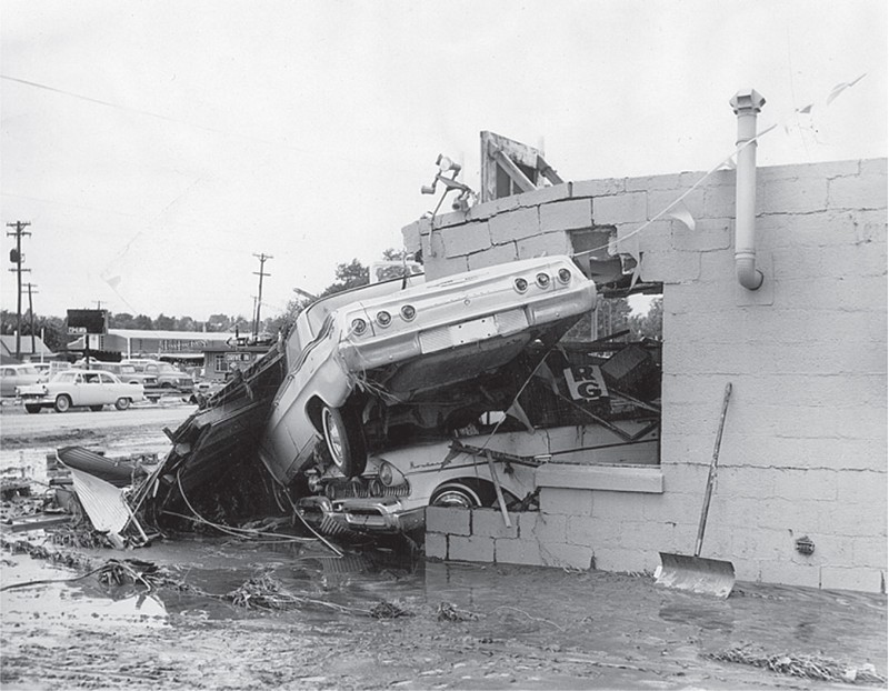
Cars piled up on West Alameda Avenue in 1965.
Denver Public Library
[
        {
          "name": "Air - MediumRectangle - Inline Content - Mobile Display Size",
          "component": "12017618",
          "insertPoint": "2",
          "requiredCountToDisplay": "2",

          "watchElement": ".fdn-content-body",
          "astAdList": [
            {
              "adType": "rectangle",
              "displayTargets": "mobile"
            }
          ]
        },{
          "name": "Editor Picks",
          "component": "17242653",
          "insertPoint": "4",
          "requiredCountToDisplay": "1",

          "watchElement": ".fdn-content-body",
          "astAdList": [
            {
              "adType": "rectangle",
              "displayTargets": "desktop|tablet"
            },{
              "adType": "rectangle",
              "displayTargets": "desktop|tablet|mobile"
            }
          ]
        },{
          "name": "Inline Links",
          "component": "18838239",
          "insertPoint": "8th",
          "startingPoint": 8,
          "requiredCountToDisplay": "7",
          "maxInsertions": 25
        },{
          "name": "Air - MediumRectangle - Combo - Inline Content",
          "component": "17261320",
          "insertPoint": "8th",
          "startingPoint": 8,
          "requiredCountToDisplay": "7",
          "maxInsertions": 25,

          "watchElement": ".fdn-content-body",
          "astAdList": [
            {
              "adType": "rectangle",
              "displayTargets": "desktop|tablet"
            },{
              "adType": "rectangle",
              "displayTargets": "desktop|tablet|mobile"
            }
          ]
        },{
          "name": "Inline Links",
          "component": "18838239",
          "insertPoint": "8th",
          "startingPoint": 12,
          "requiredCountToDisplay": "11",
          "maxInsertions": 25
        },{
          "name": "Air - Leaderboard Tower - Combo - Inline Content",
          "component": "17261321",
          "insertPoint": "8th",
          "startingPoint": 12,
          "requiredCountToDisplay": "11",
          "maxInsertions": 25,

          "watchElement": ".fdn-content-body",
          "astAdList": [
            {
              "adType": "leaderboardInlineContent",
              "displayTargets": "desktop|tablet"
            },{
              "adType": "tower",
              "displayTargets": "mobile"
            }
          ]
        }
      ]


BEFORE YOU GO...
Can you help us continue to share our stories? Since the beginning, Westword has been defined as the free, independent voice of Denver — and we'd like to keep it that way. Our members allow us to continue offering readers access to our incisive coverage of local news, food, and culture with no paywalls.
Can you help us continue to share our stories? Since the beginning, Westword has been defined as the free, independent voice of Denver — and we'd like to keep it that way. Our members allow us to continue offering readers access to our incisive coverage of local news, food, and culture with no paywalls.


Trending


Use of this website constitutes acceptance of our
terms of use,
our cookies policy, and our
privacy policy
Westword may earn a portion of sales from products & services purchased through links on our site from our
affiliate partners.
©2024
Denver Westword, LLC. All rights reserved.
Do Not Sell or Share My Information
Do Not Sell or Share My Information
